Sunday, 26 June 2011
Catalina
We spent three days in San Diego, a perfect place to get re-acclimated to life in the States. We shopped for American goods and foods that were not available in Mexico, changed our boat insurance to domestic instead of Mexican, switched from Mexican Banda Ancha (broad band) to Verizon, and generally adapted to the faster pace of life here in the USA. When we were done, we decided that it would be more fun to set a leisurely pace for our return to our home port of Long Beach.
Rising early on June 24th, we departed from our dock at Southwestern Yacht Club at 0600, bound for Dana Point harbor, about sixty miles north. Motoring out from San Diego harbor, we set a course that took us well to the south and west to avoid the extensive kelp beds off Point Loma before turning northwest toward Dana Point. With flat seas and zero wind, we motored through the chilly and overcast morning. In the afternoon the sun broke through the clouds and a light wind sprang up, but by then we were nearly at the harbor mouth. From there we motored up the channel and took a berth at Dana Point Yacht Club, where we had a nice dinner.
The next morning we slipped out of the harbor at dawn, bound for Avalon, near the east end of Catalina Island. The sky was completely overcast as we motored over a flat sea and no wind. The morning haze remained dense, keeping the island out of view until we were within five miles of it. Then the sun burst through the clouds revealing the deep green of the hills around the harbor at Avalon. We took a mooring among hundreds of other boats. Accustomed to anchoring in Mexico's tranquil waters, we experienced a bit of culture shock with paddlers, kayakers, jet skiers, and motorboaters all passing within feet, and sometimes inches of our boat. In the afternoon we went ashore and checked out some of our old haunts here, but chose to return to the boat for a quiet dinner instead of going into an overcrowded restaurant. The weekend will be over today and the hordes will head back to the mainland, and we'll move up the island to Two Harbors, where we expect to spend one more week before returning to the mainland, and our lives ashore.
Rising early on June 24th, we departed from our dock at Southwestern Yacht Club at 0600, bound for Dana Point harbor, about sixty miles north. Motoring out from San Diego harbor, we set a course that took us well to the south and west to avoid the extensive kelp beds off Point Loma before turning northwest toward Dana Point. With flat seas and zero wind, we motored through the chilly and overcast morning. In the afternoon the sun broke through the clouds and a light wind sprang up, but by then we were nearly at the harbor mouth. From there we motored up the channel and took a berth at Dana Point Yacht Club, where we had a nice dinner.
The next morning we slipped out of the harbor at dawn, bound for Avalon, near the east end of Catalina Island. The sky was completely overcast as we motored over a flat sea and no wind. The morning haze remained dense, keeping the island out of view until we were within five miles of it. Then the sun burst through the clouds revealing the deep green of the hills around the harbor at Avalon. We took a mooring among hundreds of other boats. Accustomed to anchoring in Mexico's tranquil waters, we experienced a bit of culture shock with paddlers, kayakers, jet skiers, and motorboaters all passing within feet, and sometimes inches of our boat. In the afternoon we went ashore and checked out some of our old haunts here, but chose to return to the boat for a quiet dinner instead of going into an overcrowded restaurant. The weekend will be over today and the hordes will head back to the mainland, and we'll move up the island to Two Harbors, where we expect to spend one more week before returning to the mainland, and our lives ashore.

Thursday, 23 June 2011
Back in the USA
The Honcho rested a couple of days in Ensenada, but there was no reason to stick around longer than that. So just after midnight on June 21st, we cast off for the last time from a Mexican port. It was sad to say goodbye to this country that we have come to know and love, but with a smooth sea and light winds in the forecast, it was a good time to head north to the USA. Over the last seven months we experienced much of Mexico, but we realize that there is so much more to see and do in this lovely, friendly country that we've already vowed to come back as soon as possible.
We cleared the breakwater and set a course that would take the Honcho northwest past Punta Salsipuedes and toward the Islas Coronados, the last Mexican territory before crossing the imaginary line in the ocean that marks the boundary between Mexico and the USA. We crossed that line at 0930 and almost immediately the morning haze lifted and the skyscrapers in downtown San Diego began to come into view.
At the same time, the VHF radio was crackling with warnings about a nuclear sub that would be departing from the submarine base in San Diego. It came into view when we were a couple of miles from the harbor entrance buoy and we slowed down almost to a stop to give that enormous and lethal looking warship room to pass by.
Shortly after the sub disappeared we entered the harbor and headed for the police dock on Shelter Island, where we were met by the customs agents and officially cleared into the USA. We were also met at the dock by our good friends Tom and Mary Ellen, who arranged for a guest slip for us at Southwestern Yacht Club and brought a care package of my favorite wine and some gourmet delights from Trader Joe's. We quickly squared the boat away and drank several toasts to good friends and voyages completed, then repaired to the yacht club dining room for an excellent dinner. As much as we love Mexico, it's great to be back in the USA.
 |
| Approaching Ensenada harbor. A cruise ship and the city's trademark enormous flag are quintessential elements of Ensenada's personality. |
 |
| The Honcho at the dock in CruisePort Marina. The flag is about half a mile away. |
We cleared the breakwater and set a course that would take the Honcho northwest past Punta Salsipuedes and toward the Islas Coronados, the last Mexican territory before crossing the imaginary line in the ocean that marks the boundary between Mexico and the USA. We crossed that line at 0930 and almost immediately the morning haze lifted and the skyscrapers in downtown San Diego began to come into view.
 |
| A dolphin cruises along with the Honcho, San Diego skyline in the background. |
At the same time, the VHF radio was crackling with warnings about a nuclear sub that would be departing from the submarine base in San Diego. It came into view when we were a couple of miles from the harbor entrance buoy and we slowed down almost to a stop to give that enormous and lethal looking warship room to pass by.
 |
| The photo doesn't show how big this ship is. There are a couple of sailors standing on top of the sail in this photo as it exited the harbor. Within a few minutes it submerged, bound on some mysterious mission. |
Monday, 20 June 2011
Bahia Santa Maria to Ensenada
The Honcho stayed in Bahia Santa Maria five days, waiting out the strong northwesterly wind. I was glad that I put extra large ground tackle aboard the boat, as it never gave us any reason for worry in spite of the rough conditions in the bay. When the wind finally blew itself out, the sea was still pretty lumpy, but we got the anchor up early on June 11th and headed out around Punta Hughes and northward once again. Our destination was Bahia San Bartolome, also known as Turtle Bay, about 225 miles in a northwesterly direction. Our course would take us past Cabo San Lazaro, then we would bend slightly northeast, about 25 miles east of the rhumbline, or direct line, to Turtle Bay. This course would keep us in relatively milder conditions than we would expect if we headed straight for TB. As it turned out, we had an average of about 15 knots of wind on the nose throughout the passage. During this time we were listening on the VHF radio to other boats that chose the direct route. They were facing 25 knot headwinds and rougher seas. The Honcho sailed more miles, but arrived at roughly the same time as those boats and had a much nicer ride. Sometimes it pays to go around rough conditions instead of banging headlong into them.
As we cleared Cabo San Lazaro, we observed a 60 foot ketch which had wandered too close to the Cape and foundered on the rocks that lie off the tip of the land there. We were about 2 miles off, and knew it had already been reported to the Mexican Navy, so we continued northward while monitoring the radio in case we could be of help. When we first saw the vessel it was standing upright with the mainsail hoisted, but as we watched, it began to heel over until the masts were nearly touching the water. Surrounded by large breaking surf, it would take little time for the vessel to break up. We later found that the name of the vessel was the Nordic Light, with three people aboard. The Mexican Navy rescued them but the boat was a total loss. Cabo San Lazaro has claimed many vessels over the years. It's not a place to trifle with.
With that rather grim sendoff from the Cape, the Honcho continued north and arrived in Turtle Bay at 0730 on June 13th. We anchored in the bay and quickly got Enrique "El Gordo" on the radio and ordered some diesel which he delivered in his panga at about 1000. By 1100 we had the anchor up and were once again headed north, with our next destination of San Carlos about 130 miles distant. Our course would take us northwest through the Dewey Channel and past Punta Eugenio. From there we skirted along the east side of Isla Cedros for a few miles. As we approached the northern end of Cedros, the wind piped up to about 28 knots and we opted to bear off a few degrees and make for Bahia Blanca, which is well inside the mighty Bahia Sebastian Vizcaino, where we expected easier sailing conditions. After a long, cold night of sailing we arrived at fog shrouded Bahia Blanca and waited for dawn before groping our way into the bay. There we anchored and spent the following day in comfort while the wind offshore continued to howl.
The following morning we were up early, headed for San Carlos. For most of the 55 mile passage we motorsailed directly into a light wind, but about 20 miles short of San Carlos, the wind picked up and before long we were punching into a 30 knot headwind. About three miles from the anchorage the engine died and we sailed into the anchorage under a double reefed main.
Once we were anchored I refilled the fuel tank from Jerry jugs we carry on deck. The 24 gallon tank took only 19 gallons so I knew we hadn't run out of fuel. I've gotten dirty fuel in Turtle Bay before so I checked the primary and secondary fuel filters, but they were all clean. Then I began to suspect that with all the bouncing around we did in those last few miles, maybe the pickup in the fuel tank sucked up some air. I bought a service manual for the Yanmar engine before we left California, so I got it out and reviewed the procedure for bleeding the fuel system. I carefully followed the procedure as outlined, but couldn't get the engine to start. By this time it was nearly midnight so I decided to sleep on it, maybe a solution would come to me in the morning.
The next morning I woke up early and tried bleeding the system again but had no luck. So we decided that since we had a prediction of good sailing conditions for the next couple of days, we'd pack up the tools, hoist the mainsail and sail off the anchor, bound for Ensenada where I could take a more thorough look at the engine.
From San Carlos, Ensenada is about 165 miles distant. It turned out to be a delightful sail, with winds in the 15 knot range and relatively calm seas. We sailed west past the notorious Sacramento Reef, which has also claimed a large number of ships and boats, and out about 60 miles from the coast. Tacking north from there we fetched the land just north of Cabo Colnett. Tacking offshore again, we went about 25 miles out before tacking north again. From there we could just lay the channel between Isla Todos Santos and Punta Banda, arriving at the Cruiseport Marina at 1500 on June 18th.
We had not set foot off the boat since leaving Los Cabos on June 2nd, so the first order of business was a hot shower and a steak dinner ashore, one of the finest meals we've eaten in a long time. Arriving back at the boat in the early evening, I took a more serious look at the engine, did some reading online about the fuel system and discovered a secondary bleed screw on the high pressure fuel injection pump. Within ten minutes I had the system bled and the engine running. I was very glad to get it running again without having to pay a mechanic, but I was more that a little chapped that the service manual makes no mention of this vital step in fuel bleeding procedure.
As we cleared Cabo San Lazaro, we observed a 60 foot ketch which had wandered too close to the Cape and foundered on the rocks that lie off the tip of the land there. We were about 2 miles off, and knew it had already been reported to the Mexican Navy, so we continued northward while monitoring the radio in case we could be of help. When we first saw the vessel it was standing upright with the mainsail hoisted, but as we watched, it began to heel over until the masts were nearly touching the water. Surrounded by large breaking surf, it would take little time for the vessel to break up. We later found that the name of the vessel was the Nordic Light, with three people aboard. The Mexican Navy rescued them but the boat was a total loss. Cabo San Lazaro has claimed many vessels over the years. It's not a place to trifle with.
With that rather grim sendoff from the Cape, the Honcho continued north and arrived in Turtle Bay at 0730 on June 13th. We anchored in the bay and quickly got Enrique "El Gordo" on the radio and ordered some diesel which he delivered in his panga at about 1000. By 1100 we had the anchor up and were once again headed north, with our next destination of San Carlos about 130 miles distant. Our course would take us northwest through the Dewey Channel and past Punta Eugenio. From there we skirted along the east side of Isla Cedros for a few miles. As we approached the northern end of Cedros, the wind piped up to about 28 knots and we opted to bear off a few degrees and make for Bahia Blanca, which is well inside the mighty Bahia Sebastian Vizcaino, where we expected easier sailing conditions. After a long, cold night of sailing we arrived at fog shrouded Bahia Blanca and waited for dawn before groping our way into the bay. There we anchored and spent the following day in comfort while the wind offshore continued to howl.
The following morning we were up early, headed for San Carlos. For most of the 55 mile passage we motorsailed directly into a light wind, but about 20 miles short of San Carlos, the wind picked up and before long we were punching into a 30 knot headwind. About three miles from the anchorage the engine died and we sailed into the anchorage under a double reefed main.
Once we were anchored I refilled the fuel tank from Jerry jugs we carry on deck. The 24 gallon tank took only 19 gallons so I knew we hadn't run out of fuel. I've gotten dirty fuel in Turtle Bay before so I checked the primary and secondary fuel filters, but they were all clean. Then I began to suspect that with all the bouncing around we did in those last few miles, maybe the pickup in the fuel tank sucked up some air. I bought a service manual for the Yanmar engine before we left California, so I got it out and reviewed the procedure for bleeding the fuel system. I carefully followed the procedure as outlined, but couldn't get the engine to start. By this time it was nearly midnight so I decided to sleep on it, maybe a solution would come to me in the morning.
The next morning I woke up early and tried bleeding the system again but had no luck. So we decided that since we had a prediction of good sailing conditions for the next couple of days, we'd pack up the tools, hoist the mainsail and sail off the anchor, bound for Ensenada where I could take a more thorough look at the engine.
From San Carlos, Ensenada is about 165 miles distant. It turned out to be a delightful sail, with winds in the 15 knot range and relatively calm seas. We sailed west past the notorious Sacramento Reef, which has also claimed a large number of ships and boats, and out about 60 miles from the coast. Tacking north from there we fetched the land just north of Cabo Colnett. Tacking offshore again, we went about 25 miles out before tacking north again. From there we could just lay the channel between Isla Todos Santos and Punta Banda, arriving at the Cruiseport Marina at 1500 on June 18th.
We had not set foot off the boat since leaving Los Cabos on June 2nd, so the first order of business was a hot shower and a steak dinner ashore, one of the finest meals we've eaten in a long time. Arriving back at the boat in the early evening, I took a more serious look at the engine, did some reading online about the fuel system and discovered a secondary bleed screw on the high pressure fuel injection pump. Within ten minutes I had the system bled and the engine running. I was very glad to get it running again without having to pay a mechanic, but I was more that a little chapped that the service manual makes no mention of this vital step in fuel bleeding procedure.
Friday, 10 June 2011
Bahia Santa Maria
The Honcho remained in San Jose del Cabo for several days to refuel and provision. This would be our last stop before heading north around Cabo San Lucas and Cabo Falso on the long windward jaunt back to California. The next city we will visit is Ensenada, about 800 miles north. This leg of our voyage will be the most challenging as it is all upwind, with only a very few places to stop and rest along the way. Our course will be generally northwest, directly into the prevailing northwesterly winds, so instead of shorts and t-shirts, we�ll be in fleece and foul weather gear most of the time while under way.
We departed San Jose on June 2nd, at 2100, choosing this hour because it would place us at Cabo Falso around midnight. That is typically when the wind begins to lighten and we hoped to get a few miles up the coast before the wind builds back up to its typical 20-25 knots during the afternoon. Cabo Falso collected its toll from us by delivering 25-30 knot headwinds as we rounded the cape, but after a couple of hours of that, the wind settled down and we experienced light 12 to 18 knot headwinds for the next 155 miles or so to Punta Entrada, which marks the entrance to Bahia Magdalena, or Mag Bay, as the yatistas call it. After rounding the cape, the seawater temperature began to plummet, going from the high 70�s to high 50�s in a day or so, bringing the air temperature down as well. We entered Mag Bay at 0830 and motored toward Man-O-War cove, about eight miles up inside the bay, dropping anchor there at 1030 in twenty feet of murky, smelly water.
Mag Bay was in the midst of a red tide of sorts, with millions of crawdad-like creatures that the locals call �Langostinos� dying off. Their rotting carcasses filled the water all around us and created a powerful stench in the air. To top off the situation, we were immediately swarmed by thousands of flies. We quickly fitted bug screens on the hatches, but still had to hunt down at least thirty of the pesky rascals with fly swatters. I had hoped to run our watermaker at Mag Bay to top off our water tanks, but the water was so polluted with dead Langostinos, we not only didn�t make any water, we didn�t even launch the dinghy and go ashore during the two days we spent there. It was blowing 25 outside the bay so we were content to hang out on the boat until that wind calmed down, which it did in a couple of days.
We left Man-O-War cove early in the morning on June 6th, glad to get away from the reeking air, foul water and flies of Mag Bay. We cleared Roca Vela and set a course for Bahia Santa Maria, about 14 miles distant in about 10 knots of northwesterly wind. As we approached Cabo Corso at the southern end of Bahia Santa Maria, the wind and seas began to build, and within a few minutes we had a 20 knot headwind and 6 foot seas. I altered course to sail further into the bay, thinking we would get a little protection from the high hills at the northwest end of the bay, but the winds and seas continued to increase until we finally made it to the anchorage in the northwest corner of the bay, where we got the hook down in 20 feet of roiling water and 30 knot winds.
We�ve remained at anchor here, staying mostly inside the boat while the wind howled outside for three days in the 25-35 knot range, with occasional gusts to 40. With little to do besides checking for wear on our ground tackle and making sure things were secure on deck, we spent those days reading , watching movies and monitoring weather forecasts on the internet and the HF radio. The weather began to ease yesterday and it looks like we�ll have a nice window to make our next passage north beginning on Saturday night, June 11th. Our plan is to clear Cabo San Lazaro around 0100, then work our way north toward our next planned destination, Turtle Bay (Bahia San Bartolome), about 225 miles distant. Rather than banging straight up the rhumbline, we�ll sail a course well to the east where we can expect lighter conditions. This course gives us the option of ducking into San Juanico, Abreojos or Asuncion, which are small anchorages along the way, in case the weather turns against us.
There are several other boats here in Bahia Santa Maria with us, all waiting for the expected weather window. Among them are the following:
Manta 42 Catamaran
Norseman 447 cutter
Catalina 400 sloop
Seawind 1000 Catamaran
Catalina-Morgan 45
CT-54 ketch
Thursday, 2 June 2011
The Cape
After San Juanico, the Honcho hurried south to La Paz where we spent a couple of days to refuel and reprovision. On May 28th we left La Paz for Puerto Balandra, a favorite of ours, where we spent the night tucked into the southwest cove. The Coromuel wind blew hard all night and into the next morning, but by 1100 it had settled down to a 15 knot southwesterly and we got underway, bound for Ensenada de Los Muertos, on the east side of the cape. Our course took us north, then east through the Canal de San Lorenzo and then southeast through the Canal de Cerralvo. There the wind turned southeast, exactly the direction we wanted to go. It brought with it a southeast current of about a knot, so it was a slow passage through that channel.
The Honcho arrived at Los Muertos about 2030 and got the anchor down just after the sun set over the mountains. The southeast wind died at night but the swell didn't and we spent a fairly rolly night in the anchorage there. We were on the move again at dawn, bound for Bahia de Los Frailes, about 45 miles down the coast. After the sun rose, the southeast wind returned and the Honcho punched into it for about eight hours, arriving at Los Frailes around 1700. Los Frailes is open to the southeast and thus was not a suitable anchorage with a fairly heavy southeast sea rolling in. We gave it a look and decided to continue on to San Jose del Cabo.
An hour or so later the wind turned around and blew 20-22 knots out of the northeast, bringing a following sea with it and we made a quick passage to San Jose, arriving in the harbor after dark, about 2115 on May 30th. It was a moonless night and we had never been into the harbor. On top of that, the harbor is new and our charts don't show it. We pulled out the I Pad with its Navionics navigation software and used it to navigate the last mile to the harbor. I think that software is based on satellite photos instead of charts that were originally made back when the Spaniards were running the show around here, and are very accurate. In the future we'll convert all of our navigation gear to this technology.
We are now in San Jose del Cabo, refueled and ready to begin the last portion of our voyage, the 900 or so miles up the west coast of Baja to Long Beach, CA. With northwesterly winds dominant on this coast, which is exactly the direction we want to go, we'll sit tight here in San Jose and wait for those winds, which have been blowing hard recently to lie down a bit.
Our course on the first part of this passage will take us northwest along the Baja coast to Man-O-War Cove, inside Bahia Magdalena. Then we'll head for Bahia Santa Maria, Bahia San Juanico, Punta Abreojos and Turtle Bay, where we'll spend a few days.
The Honcho arrived at Los Muertos about 2030 and got the anchor down just after the sun set over the mountains. The southeast wind died at night but the swell didn't and we spent a fairly rolly night in the anchorage there. We were on the move again at dawn, bound for Bahia de Los Frailes, about 45 miles down the coast. After the sun rose, the southeast wind returned and the Honcho punched into it for about eight hours, arriving at Los Frailes around 1700. Los Frailes is open to the southeast and thus was not a suitable anchorage with a fairly heavy southeast sea rolling in. We gave it a look and decided to continue on to San Jose del Cabo.
An hour or so later the wind turned around and blew 20-22 knots out of the northeast, bringing a following sea with it and we made a quick passage to San Jose, arriving in the harbor after dark, about 2115 on May 30th. It was a moonless night and we had never been into the harbor. On top of that, the harbor is new and our charts don't show it. We pulled out the I Pad with its Navionics navigation software and used it to navigate the last mile to the harbor. I think that software is based on satellite photos instead of charts that were originally made back when the Spaniards were running the show around here, and are very accurate. In the future we'll convert all of our navigation gear to this technology.
We are now in San Jose del Cabo, refueled and ready to begin the last portion of our voyage, the 900 or so miles up the west coast of Baja to Long Beach, CA. With northwesterly winds dominant on this coast, which is exactly the direction we want to go, we'll sit tight here in San Jose and wait for those winds, which have been blowing hard recently to lie down a bit.
Our course on the first part of this passage will take us northwest along the Baja coast to Man-O-War Cove, inside Bahia Magdalena. Then we'll head for Bahia Santa Maria, Bahia San Juanico, Punta Abreojos and Turtle Bay, where we'll spend a few days.
Friday, 27 May 2011
Bahia de Concepcion
The days are rolling by ever so quickly and we have many miles to go, and many places to see before we say adios to Mexico. So we have hurried along on our voyage, reaching Bahia de Concepcion on May 17th. Our route from San Evaristo took us to Bahia Agua Verde for a night, then to Puerto Escondido for a couple of days. From there we went to Caleta San Juanico, where we anchored again for just a night. We then anchored in Bahia de Concepcion in a small cove between Playa Santispac and Posada Concepcion.
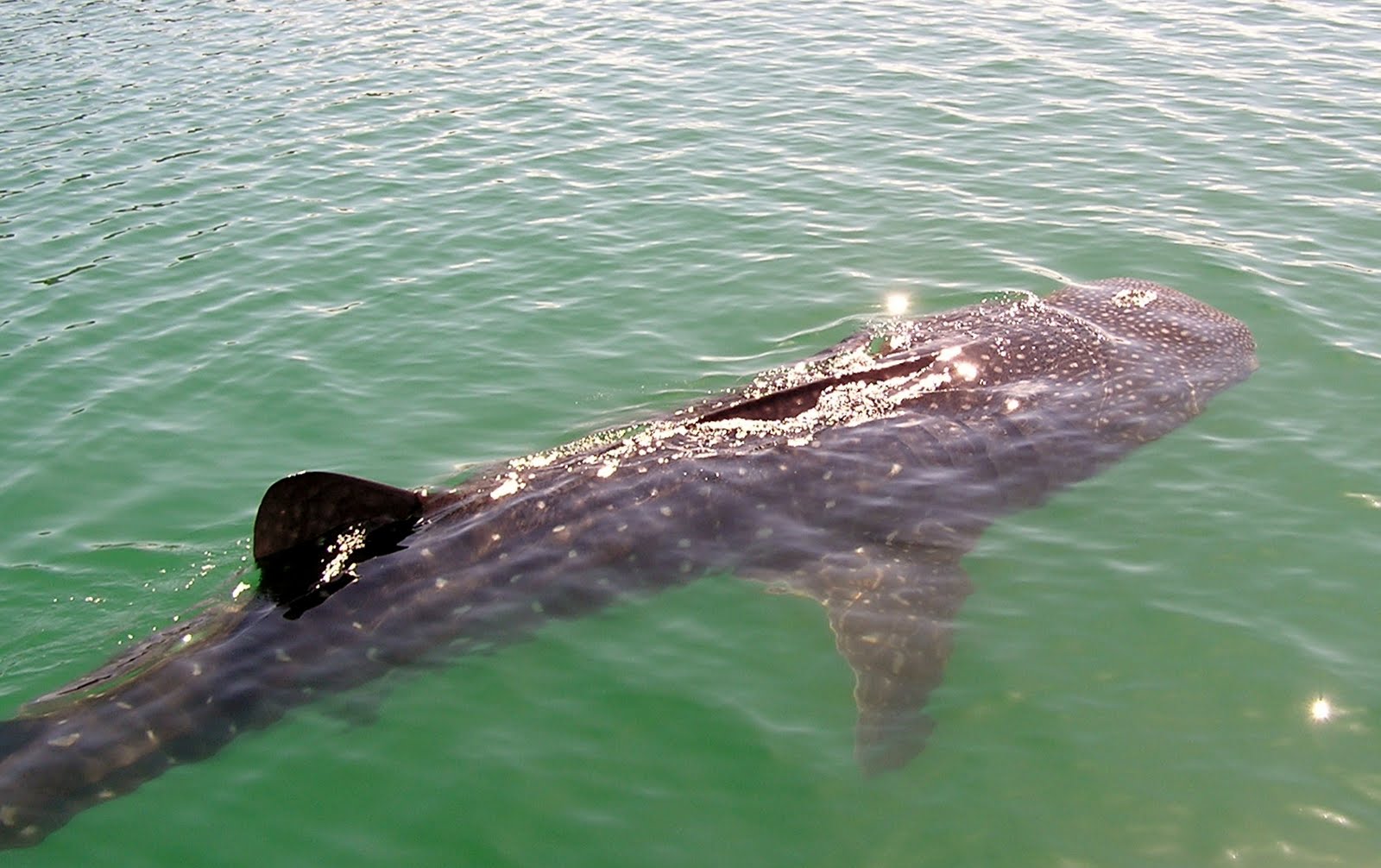
Bahia de Concepcion is about 20 miles long and roughly 4 miles wide. It is dotted with many small islands and is home to a wide range of birds and marine life. After a nice dinner ashore and a good night�s rest, we were up early the next morning, cleaning accumulated salt off the boat and rigging. Suddenly we were distracted by a slight commotion in the water and discovered a couple of whale sharks lazily feeding next to the boat. We watched and photographed them for a while then donned mask and fins and joined them for a swim. Whale sharks feed on plankton and other small sea life and don�t pose a predatory threat to humans. We dove under water and could see the massive fins and gaping mouths of these animals as they passed by close enough to touch. Predatory or not, swimming that close to such a large animal was exciting!

At Puerto Escondido there is a large and very well protected lagoon with at least a hundred moorings, a fuel dock, tienda and other amenities including internet access, which is rare in this part of the world. We took advantage of all of these as well as the fine restaurant there.
 |
| Dawn in Puerto Escondido |
After a couple of days at Puerto Escondido, we continued north another forty miles to Caleta San Juanico. Arriving there around 1600, we got the hook down in about 30 feet of water and had a nice swim before dinner. At roughly 26 degrees north latitude, San Juanico is far enough north that there is a bit of coolness in the air in the evenings, which is a refreshing change from the dry heat of La Paz.
 |
| San Juanico sunrise |
 |
| The Honcho trolling with a Mexican lure. It's called a Mexican because it is red, green and yellow; The same colors as the Mexican flag. We've had the most luck with this lure, hooking innumerable Jacks, yellowfin, even a striped marlin. |
Bahia de Concepcion is open to the north, so after clearing the entrance the Honcho bore off and had a quick downwind run in 20 knots of wind toward Playa Santispac. As we approached Santispac we could see the north wind raking through the anchorage so we continued a bit further to a small cove just east of Posada de Conception and dropped the anchor in 20 feet of water, about 60 yards from shore. With steep hills to our north coming right down to the water�s edge, we are well protected from the wind.
 |
| An eighteen foot whale shark glides past the boat in Santispac. The fin to the left is the dorsal, to the right is the tail. |
Bahia de Concepcion is about 20 miles long and roughly 4 miles wide. It is dotted with many small islands and is home to a wide range of birds and marine life. After a nice dinner ashore and a good night�s rest, we were up early the next morning, cleaning accumulated salt off the boat and rigging. Suddenly we were distracted by a slight commotion in the water and discovered a couple of whale sharks lazily feeding next to the boat. We watched and photographed them for a while then donned mask and fins and joined them for a swim. Whale sharks feed on plankton and other small sea life and don�t pose a predatory threat to humans. We dove under water and could see the massive fins and gaping mouths of these animals as they passed by close enough to touch. Predatory or not, swimming that close to such a large animal was exciting!
 |
| Kayaker stalks a big one |
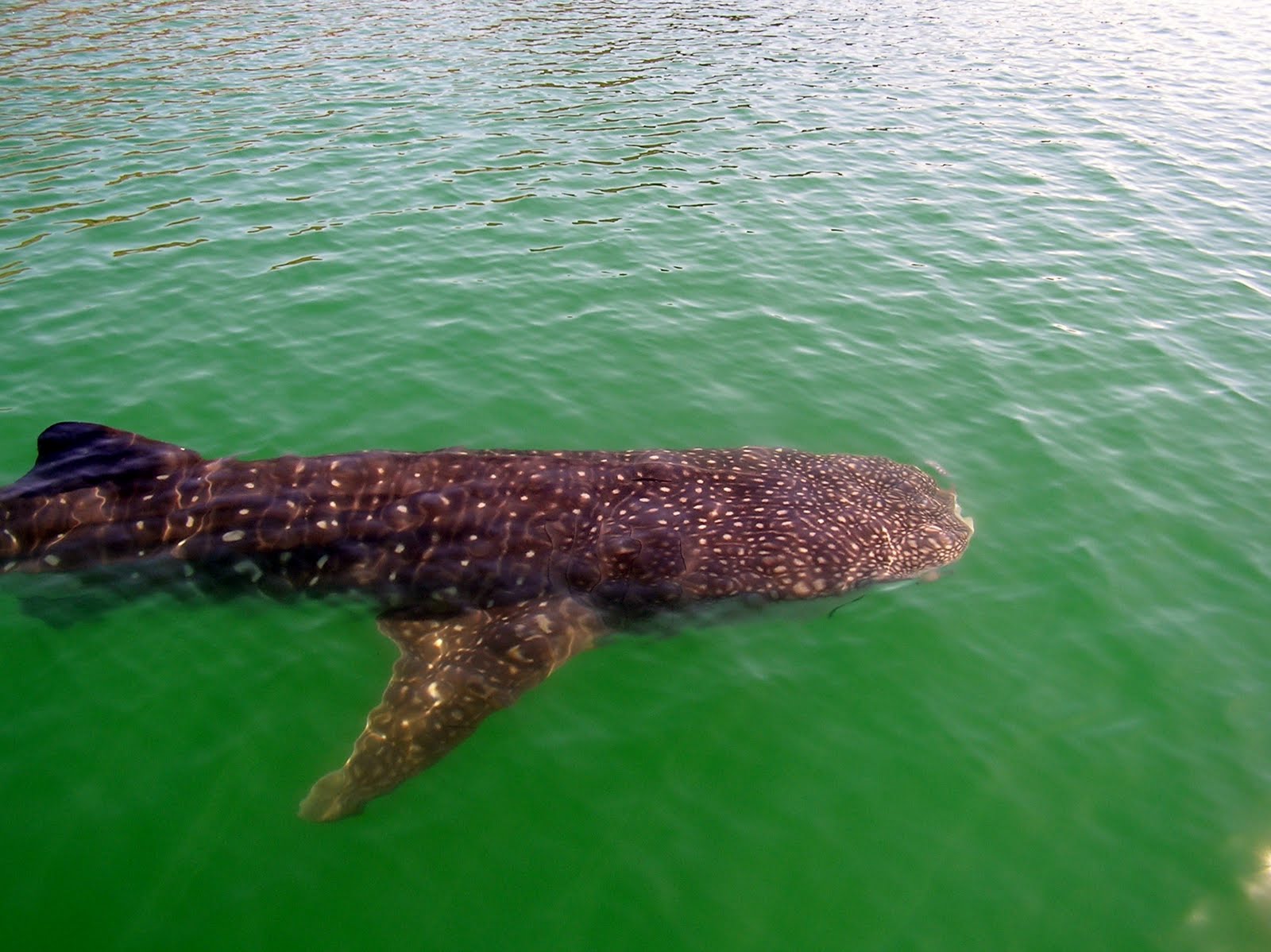 |
| This shark is about 18 feet long and has a wingspan of about eight feet, near as I could estimate. Whale sharks feed at or near the surface of the water, drawing large gulps of seawater, then expelling it out through their large gills, which have filtering elements that strain out the plankton and other small sea life. The water in Bahia de Concepcion is full of nutrients, which makes underwater visibility not nearly as good as at places like Isla San Francisco. |
Playa Santispac is pretty much the boonies and there are no services here�no taxis, internet, cell phones, or gas stations. In need of diesel fuel, we took a couple of jerry cans and wandered up the beach, trusting that somehow we�d find a way to get to the nearest gas station, thirteen miles up the road. Sure enough, before long we�d hitched a ride on an old beat up water truck that took us all the way to the Hotel Serenidad where we had a fine lunch of fish tacos, guacamole and ice cold beer. We then got the fuel and a ride back to the beach in Santispac, where we�d left our dinghy. From there it was a short mile back to the boat.
The next day we were again visited by the whale sharks, but didn�t swim with them as we had plans to visit the town of Mulege, where we spent most of the day touring this flood ravaged town and socializing. Mulege suffered a direct hit by Hurricane Jimena a couple of years ago. Much of the town was damaged or destroyed by the storm, which caused the Rio Mulege to overflow its banks, washing a good portion of the town into the sea. There are still many signs of destruction in this pleasant little village.
Bahia de Concepcion is as far north as we will get on this voyage. So when we weighed anchor Saturday morning, May 21st, we were southbound, headed back toward San Juanico, where we spent a couple of days. It was a delightful sail during which we were able to fly the spinnaker for a few miles before the wind shifted to the southeast and we were forced to set the trusty jib for the last twenty miles. Along the way we caught an 8 pound yellowtail, which we barbecued with friends from the sailing vessels Stray Cat and Capriccio in Caleta San Juanico. San Juanico is a fairly large bay, with good protection from northerly and southerly winds, but is open to the southeast, which is where the wind has been for the last couple of days, forcing us to shift to a snug anchorage in the lee of some large rocks in the northern reach of the bay. There are dramatic rock formations here, a beautiful freshwater lagoon and a kind of shrine or monument where passing yatistas put up plaques and inscriptions made of anything from old sandals to beautifully carved wood, usually with a boat and crew names and dates. It was interesting to see the names of many boats we�ve come to know hanging in the tree that makes up the shrine. This passage is the first of the truly homeward bound portion of our voyage. We�ll continue south to Cabo San Lucas, stopping at various places along the way, where we�ll provision and secure the boat for the last long leg of our voyage, the long windward passage up the west coast of Baja to our home port of Long Beach.
 |
| The volcanic rocks in San Juanico. Fantastic colors and shapes |
 |
| It was surprising to see this sparkling freshwater lagoon just a short walk from the beach in an otherwise torrid desert landscape. |
Monday, 23 May 2011
San Evaristo
The Honcho sailed from Isla San Francisco on Wednesday, May 11th. We had planned to head directly for the village of San Evaristo on the coast of Baja, but at the last minute decided to detour to Isla Coyote, a tiny island that lies between Isla San Francisco and Isla San Jose, only about 2 miles away. The wind was blowing out of the northwest about 15-18 knots and the only anchorage at Isla Coyote is an open roadstead and completely exposed to the prevailing wind and seas. With unfavorable conditions at Isla Coyote, we bypassed it and proceeded on to Bahia Amortajada, on the southern tip of Isla San Jose, only three or four miles further. Sailing in company with two other boats, Blue Rodeo & Swift Current, we came to anchor on the south side of the sand spit that makes the bay in about 15 feet of water. We had heard about an interesting lagoon here and quickly jumped into Blue Rodeo�s dinghy and found the entrance to the lagoon, which was only about a foot deep so we lifted the engine and walked the boat through the pass and entered the lagoon. Once inside the lagoon we motored up the estuary, which was teeming with fish and birds of many varieties. After an hour or so, we returned to our boats and prepared to cross the Canal de San Jose to the village of San Evaristo.
 |
| Looking west from the lagoon on Isla San Jose across the channel toward the mainland of Baja and the Sierra de la Giganta mountains. |
 |
| Wildlife in the lagoon, Isla San Jose |
When we cleared the southern tip of Isla San Jose, the wind piped up to 20-22 knots with steep 4 foot seas. Punching into this, the Honcho could just make about 4 knots, with spray flying. It was only about 7 miles to San Evaristo so we soldiered on, a bit dampish but enjoying the view of the white flecked sea. Around 1600 we came to anchor in a snug cove just off the village of San Evaristo, well in the lee of some steep hills.
San Evaristo is typical of many fishing villages that dot the Baja coast, with a small tienda, beer �Collectivo� (where you can buy beer), small water desalinization plant, and a small elementary school. All of which serve the twenty or so families living here as well as the salt farmers and rancheros who live in the surrounding area. One day we walked over the hill behind the village and came to the salt ponds, a mile or so away. It was a sweaty walk on the dusty road under the blazing sun. On the way we shared the dirt road with wild burros and hardy Mexican cattle. Skittish at first, the burros eventually relaxed enough to pose for a couple of photos. Looking out over the salt pans, I saw a lone worker in the distance raking salt into piles. He looked miserable in the hot sun with his rake and vast piles of salt around him.
 |
| Salt ponds at San Evaristo |
 |
| These burros darted into a thicket when we surprised them coming around a bend in the road. Once we passed by, they came back onto the road, watching us and following about 50 yards behind us. |
 |
| We saw several of these critters browsing on the steep hillsides near where we anchored. |
 |
| Cardon Cactus |
It seems like cactus grows everywhere in Baja. The Cardon, one of the most noticeable, is a remarkable plant...or tree. It is thought to be the tallest cactus species in the world, reaching more that 60 feet high. Natives of the area use the fruit of the Cardon as a food source. It also is known to contain alkaloids, and is reputed to have psychotropic properties. We didn't try any, as food or drug. These cacti can apparently grow on bare rock because their roots provide a haven for certain bacteria and fungi that can extract nitrogen from the air and chemically break down rock to extract nutrients. Pretty cool stuff.
We spent a couple of days in tranquil San Evaristo, then headed north toward the green waters of a place called Agua Verde (Green Water). We'll see.
 |
| A calm day in the Sea of Cortez, northwest of Isla San Jose. |
Subscribe to:
Posts (Atom)


.jpg)


